


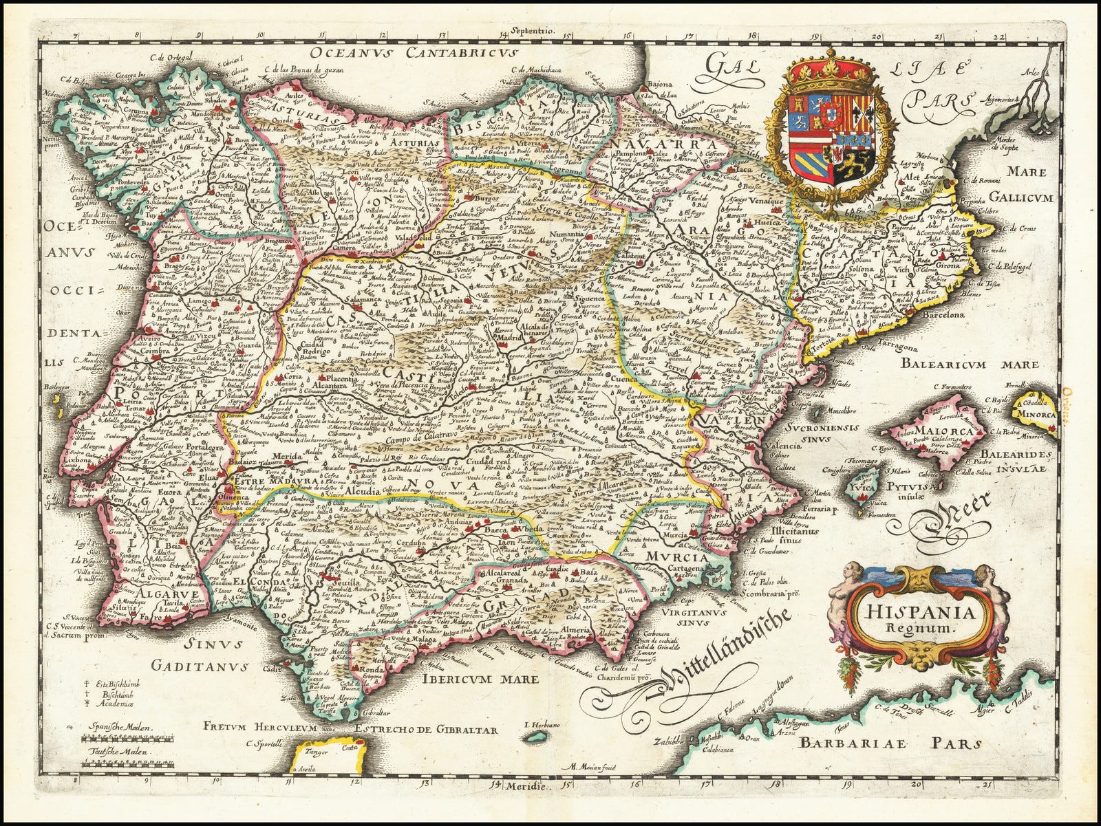
Hispania Regnum
A stunning Swiss map of Iberia and some implicit family feuds.

Introduction
Published in 1638 in Frankfurt by Matthäus Merian in Neuwe Archontologica Cosmica, Hispania Regnum is a remarkable piece of 17th century cartography. Such a map displays not only hundreds of locations, but also the borders of each and every Iberian province under the rule of the Spanish Habsburgs.
These frontiers not only exhibit the inherent cultural diaspora of the Peninsula, but also the old tensions that have made this landmass what it is. Granada, for example, has the same shape as it did when it was the last independent Islamic nation in Iberia. Aragón, Catalonia and Valencia’s borders make up the form of the Crown of Aragón right before its union with Castilla. And, of course, Portugal stands in the west as it did right before the Iberian Union.
Furthermore, while Felipe IV (of Spain, III of Portugal) had various titles such as King of Galicia or León, what is seen in the map seem to be provinces, not Kingdoms. This distinction is at the heart of Iberian geopolitics, and some of these family feuds will be further explored.
However, first an honorable section dedicated to the author of this wonderful map.
The author
Matthäus Merian was born in 1593 in Basel (Switzerland), and learned his trade in Zurich. Becoming skilled in copperplate engraving, he worked most of his life in Frankfurt, specializing in city plans and panoramas. He designed many important works, such as city plans for Paris, Genoa, Lisboa and Mainz.
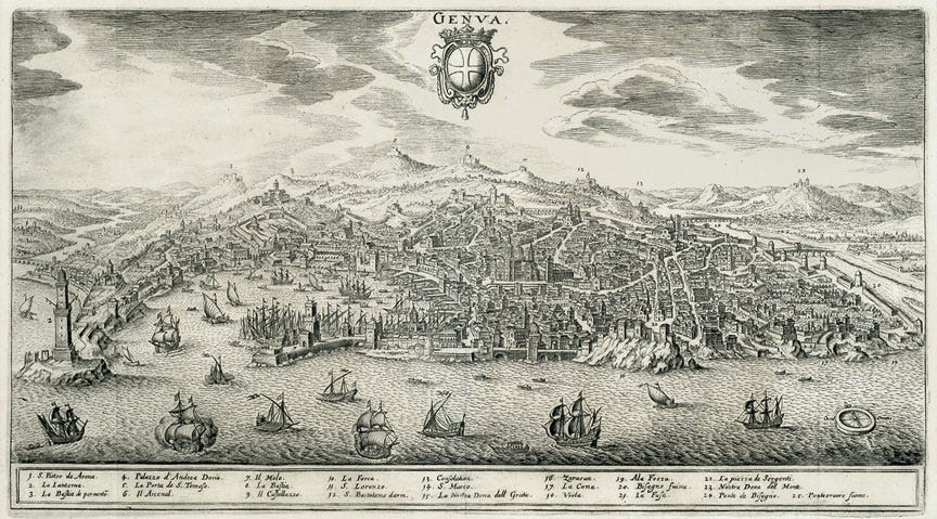
Panoramic view of the city of Genoa, an important center of Mediterranean trade.
Pieces of art and craft like city plans can easily go unnoticed but it is often because of endeavors like Merian’s that we know how current cities looked and felt like hundreds of years ago. Works from these artists allow us to get a glimpse at the aesthetic of times of yore.
We may visit or live in a city filled with modern buildings, sometimes passing by an old area or even a single piece of ancient architecture. Don’t we ask ourselves what it looked like when all our surroundings were filled with these old looks?
While we can’t rebuild entire cities, we can observe works such as Merian’s to have a better notion of those times, thereby also bringing honor to the efforts of such professionals.
Additionally, knowing that in those times the artistically inclined tended to be gifted in more than one field, Merian was also a skilled painter as can be seen in the picture below.

Portrait of Gustavus Adolphus of Sweden, by Matthäus Merian.
Neighbors & Roommates
Like any other earthly landmass with a collection of various peoples, the Iberian Peninsula provides a long and complicated history between its inhabitants, and it is under the pretext of Hispania Regnum that some of those relationships will be explored in this section.
Hispania & Spain
The elephant in the room is, of course, the difference between the region and the country, or if there is one in the first place.
Hispania was the name given by the Romans to the Iberian Peninsula, and within the region were provinces such as Baetica (modern day Andalusia) and Lusitania (modern day Portugal). So indeed Hispania is meant as the name for the whole “plot” of land.
Spain, the country, started getting its name from the merger between the Kingdom of Castilla and the Crown of Aragón, through the matrimony of Isabel of Castilla and Ferrando II of Aragón in 1469. Isabel’s possessions stretched from Galicia to Múrcia, whereas Ferrando’s included lands as far as Sicily. The union between both realms would only officially become Spain in 1516 under Karl V, yet the term likely started being used de facto when Isabel and Ferrando II joined forces in marriage. For example, the Spanish Empire started in 1492.

Crest of Felipe IV of Spain (1605-1665). Sicilian heraldry in the top right corner.
So essentially, this fusion gained immense prestige in the eyes of all European courts, and (eventually) naming this new nation after the Roman designation for the Peninsula only increased its grandeur.
Yet at the time of this Iberian Wedding, Navarra, Granada and Portugal were still independent countries in the north, south and west of Iberia, respectively. Then, strictly speaking, Isabel and Ferrando II’s new merger nation started being named after Hispania, without it all being united under one banner. Perhaps such branding might have given the Navarran, Granadan and Portuguese of the time a hint at future political ambitions in the region.
Provinces & Kingdoms
At the time of Hispania Regnum, 1638, the Iberian political scene was already quite different from that of Isabel and Ferrando’s time. The Emirate of Granada was no more (capitulation in 1492), the Kingdom of Navarra was conquered in 1512, and the Peninsula was living 58 years of what was called the Iberian Union.
To summarize, Portugal suffered a succession crisis after the death of King Sebastião in 1578. Felipe II of Spain had a strong claim to the Portuguese throne, as he was the grandson of Manuel I of Portugal, who was famous for his empire in Africa and India, and for gifting an elephant called Hanno to Pope Leo X. Thus Felipe II was smart and took the opportunity to become King of Portugal, and successfully doing so in 1580.

Portrait of King Sebastião, “O Desejado”, by Cristóvão de Morais.
The intriguing nuance of this union was that Felipe II kept Spain and Portugal as two separate countries. He was King of both, yet they had separate governmental courts, judicial systems, currencies, and (theoretically) navies and armies.
A similar situation happened to his father, Karl V, who was both King of Spain and Archduke of Austria, among many other titles. Austria did not become part of Spain and vice versa, yet he was ruler of both realms. In fact, Karl V was even Holy Roman Emperor, but Spain was not incorporated into the Holy Roman Empire, nor did this confusing government become a subject of Spain.
So under Felipe II’s reign, this system worked reasonably well, and with Felipe III too. However it was under Felipe IV that animosities between the Spanish and the Portuguese grew strong again, because he wanted to make Portugal a province of Spain. Note that the map was drawn during Felipe IV’s reign and that Portugal was still under his rule.
Matthäus Merian’s map implicitly suggests why Felipe IV could have pushed for such a resolution, and consequently why the Portuguese proceeded to declare independence from Spain two years later, in 1640, with the Brigantine Dynasty.
The fact stands that many of the displayed provinces in Hispania Regnum were once independent Kingdoms. So why should Portugal be the exception? And if it was so, then why were provinces such as Catalonia or Granada not an exception too? After all, they either had strong historical claims for autonomy, or were important centers of trade that could easily be self-governing. If there were to be exceptions in the first place, what was the threshold dictating one province being worthy of self-rule and another not so much?
This is not a claim that fear of general insurrection was the main driver for wanting to turn Portugal into a province, but the question naturally arises, merely as a possibility: “If Portugal can do it, why can’t we?”
Hence, the display of these provinces in the map is inherently an exposition of different peoples under the rule of the Spanish Habsburgs. The coat of arms shown above provides proof of that, as Felipe IV’s crest included the heraldry of Castilla, León, Portugal, Granada, Aragón, and even realms outside the Peninsula such as Austria or Sicily.
Such questions as the ones made above can easily spill into contemporary debates, although this is not the focus of the article. Instead, it is simply a reflection of the old and deep relationships between Iberian cultures, and how many of these aspects have lived through multiple generations in the Peninsula.
An interesting comparison is that of the Italian Peninsula. Italy at the time was a collection of small states with cultures and dialects that had common aspects, but also many unique characteristics to each nation. A Florentine could understand a Venetian, but each had their own mode of being; and at the end of the day they did not belong to the same country, so although they could compete and even fight for power, each could essentially be left to their respective lands. This meant that while these small states could be at war with each other, they also could engage in peaceful trade, as no one was forced to live with someone who didn’t share in their customs or tongues.
This situation contrasts with that of the Iberian Peninsula, where the entire territory was, at the time, ruled by a single dynasty. So while the Spanish Empire gained immense power from this centralization, it also meant there was the risk of provincial neighbors becoming roommates instead: sounds great in the first few days, but after a while it’s Lord of the Flies.
Islamic Heritage
Curiously enough, the city state system had already been tested in Iberia before, and with surprising originality.
Starting from 756 AD, already during the Reconquista, the Emirate of Córdoba lived on with a remarkable culture for its time. The ruling class was Sunni, yet Córdoban society included many Christians and Jews. It was legal to practice one’s faith, albeit with some monetary incentives to convert to Sunni Islam. Much like in the Middle East, Al-Andalus (the name given to Iberia by Muslims) was filled with Universities and Libraries relentlessly translating works from Greek, as well as producing science, philosophy, and beautiful poetry.
Córdoba was a single country, but from 1009 to 1110, 1140 to 1203, and finally from 1232 to 1287, Al-Andalus lived through the Taifa Periods. These were small independent city states that, much like Renaissance Italy, competed militarily, but also culturally, scientifically and for prestige. Tolerance still existed because no Taifa had the incentive to be discriminatory, since a large part of the Andalusian scientific and cultural explosion was there because of the presence of various peoples. So if a Taifa decided to be discriminatory, Jews and Christians would simply migrate to the neighboring Taifas, taking their science, philosophy and art with them.
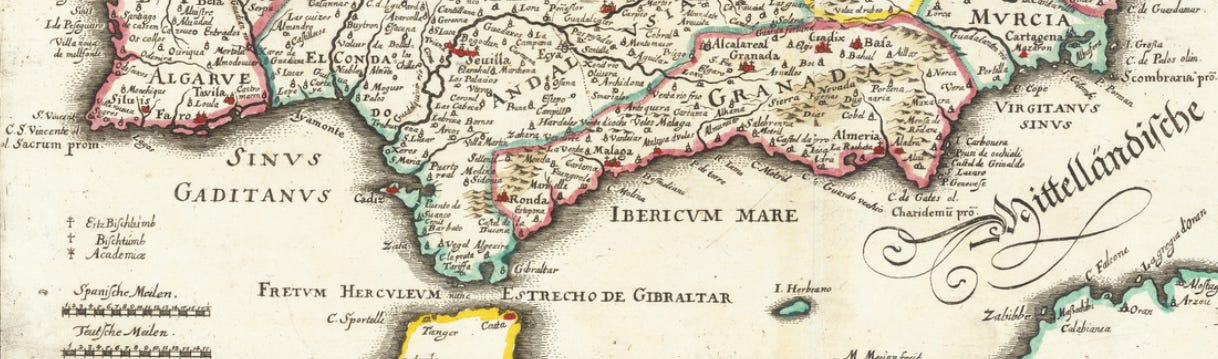
Southern part of Iberia in Hispania Regnum.
As can be seen in the picture above, the remnants of this “Proto Renaissance” are imprinted in the map: Andalusia alludes to Al-Andalus; the Algarve existed not only as a Portuguese province but as a Royal title to the Portuguese King, as it was conquered from Taifas such as Silves and Mértola; and Granada retains its shape from when it was the Emirate of Granada.
These borders also reveal the gradual decline of the levels of cooperation that were achieved by the Taifas, as well as the subsequent increase in hatred between people of different creeds. The Emirate of Granada was preceded by the Almohad Caliphate, and these were preceded by the Almoravid Dynasty. These Kingdoms conquered the Taifas before the Christian nations in the North, and already in this period there was immense persecution against Jews and Christians, which led the survivors to flee northwards and for Reconquista momentum to pick up. It also shows the subsequent brutal persecution of Muslims and Jews -in Spain and Portugal- when the Kingdom fell to the combined forces of Isabel and Ferrando II.
In short, the South displays a time when Muslim, Christian and Jew could live in peace with each other. This because each group had wisdom and know-how to add to society and because of the Mechanism Design of Taifas: being friendly neighbors with the other creeds means a Taifa gets science, culture and poetry; and it also means the same Taifa retains such generational knowledge, or at least prevents it from migrating.
Last Words
As can be observed, there is a lot of explicit and implicit History in a map. Iberia is mostly seen today as Spain and Portugal, yet there are deep and complex stories -many of them local rather than global- that made this landmass a unique place.
Under the pretext of Hispania Regnum, it was possible to observe the works of Merian, contemplate some intricacies of various Iberian peoples, and hopefully bring honor to both.